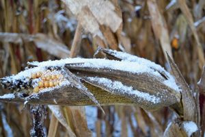
Weekend Winter Storm to Halt Crop’s Progress

Portions of the Corn Belt planted late this spring, and the effects may be felt soon.
Among the top 18 corn-producing states, 58% of the corn is mature in the week ending October 6, according to the USDA Crop Progress Report. This year sits behind the five-year average (85%) and in 2018 (92%) at this point in the year.
The USDA reports 93% of the corn is in the dent stage, falling behind the five-year average of 99%.
A winter storm system rolling through the Rockies could soon threaten these slowly maturing crops across the northern Plains and Midwest that are already well behind schedule.
USDA Chief Meteorologist Brad Rippey says the storm could cause yield losses in northern Iowa and Minnesota. “Almost all of the corn has at least reached the dented stage there, so you might take a few percentage points off yield potential because it is dented but hasn’t reached full maturity,” Rippey said.
A very small percentage of crops in the far northern production areas “could be lost entirely” if the freeze comes in and nips the crop as expected, he said.
SNOWSTORM EXPECTED
North Dakota is no exception to the delayed corn maturity, coming in at 84% dented and 22% mature, according to the USDA. The average in the week ending October 6 is 98% dented and 75% mature.
In South Dakota, the USDA lists the corn slightly ahead of North Dakota with 91% dented and 36% mature (99% dented and 80% mature is the five-year average).
North Dakota faces potential snow later this week, beginning on Thursday.
“There’s going to be a major change in the [weather] pattern later this week,” says AccuWeather meteorologist Dale Mohler.
Mohler says the change in weather won’t be too negative for most of the Corn Belt, but the northwest portion will be affected the most.
“What’s going to happen is there’s going to be a period of rain — probably about a .5 inch to 1 inch in a lot of places — and then it’s going to turn a lot cooler,” Mohler says. “Most of the belt, it won’t be cool enough for a frost or freeze, but in the northwest corner it will, and in the far northwest — up in the eastern Dakotas — they’re going to get pounded by a very heavy, early-season snowstorm.”
That region could see between 12 and 24 inches of snow, according to Mohler.
While the cold could damage crops in the Dakotas, Mohler also sees reason for concern with the strong wind brought in with the snowy weather.
While the Dakotas battle the snow, the border states will also see temperatures dip and precipitation.
“It’s just not a good situation up in the northwest corner,” Mohler says. “Things won’t be quite as bad for most of the crop damage in Nebraska, Iowa, and Minnesota. It’ll be windy, a lot colder, rain, maybe a few snow showers, but I don’t there’s really much significant, if any, accumulation in most of those crop areas.”
After the stretch of precipitation around the western parts of the Corn Belt, the weather switches to more favorable conditions.
Next week could start a little chilly, according to Mohler, but the rain will stay away. The week is set to stay mostly dry until the weekend, which could bring some showers.
When the second half of the month arrives, Mohler expects the weather to fall into a more normal pattern.
“It looks like the second half of October — probably a little drier than normal in the eastern part of the Midwest and maybe near or a little bit wetter than normal in the west,” Mohler says.
Aside from the precipitation, Mohler says he expects temperatures to stay normal in the second half of October, hovering in the 50s and 60s during the day and falling to the 30s and 40s at night.
While the west portion of the Midwest faces obstacles with rain, snow, and cooler temperatures, the southeast area of the Corn Belt saw dryer conditions in September.
Southern Illinois, Indiana, and Ohio feature areas with light to moderate drought conditions, according to the USDA Drought Monitor released on October 3.
Mohler expects the area to see rain occasionally, including a potential .5 inch on Friday from the front rolling through and causing the precipitation in the western parts of the Midwest.
“No all-day rains; I don’t see that right now down there,” Mohler says about the area’s outlook. “That could happen a couple more times later this month — a front goes through and gives them rain for maybe six to eight hours, or 10 hours, and then it moves on and you get a six- or eight-day stretch of dry weather.
“It looks pretty favorable in the east, overall.”
Source: AgriMarketing, Agriculture.com
